Contents
Index
Advanced Cleanup
This option has a selection of tools to perform set tasks on a data set.
Some of the options are only relevant in some states of Australia, for example ILIS parcels in the NT.
So the menu of available items will change depending on the "STATE" variable in the config file.
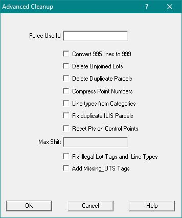
Dialogue box for Nothern Territory users
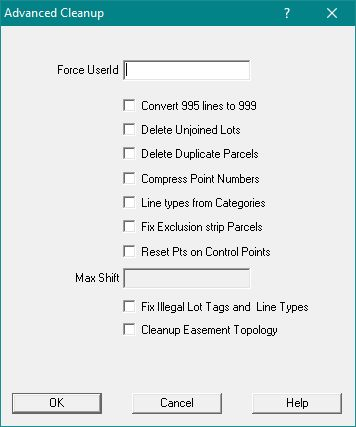
Dialogue box for users outside the Nothern Territory
Force UserId
This will force all parcel to have this userid.
Convert 995 lines to 999
This option will find any parcel line coded 995 and change them to 999.
This is done for joined and unjoined parcels.
Delete Unjoined Lots
This is a quick way to get rid of all the unjoined parcels in the job.
Delete Duplicate Parcels
This searches for any parcels with the same lot name and plan name
and deletes the second one.
If one of the parcels is joined, it will delete the unjoined parcel.
Compress Point Numbers
This changes the point numbers in the job to start from 1 and eliminates any gaps in the point numbers.
Line Types from Categories
This is mainly used for jobs which have been created by the parcel editor in ArcMap.
Parcel editor sets line categories but not line types.
The routine will automatically set line types using the default settings for each category.
Fix Duplicate ILIS parcels (NT jobs only)
For each ILIS parcel (type=666) it will search for a "Non ILIS" parcel with the same name and plan.
If one is found, it will delete the ILIS parcel.
Then it will list all plans and parcels without a dbid
Fix Exclusion Strip Parcels parcels (Jobs outside of NT)
In Queensland (and maybe in other places) exclusion strips are used to prevent the owner of a lot from having access to a road.
Typically these may be only 100mm wide and may extend for a considerable distance.
This type of structure can cause problems in the adjustment, so it is necessary to add connections and other information in order to enforce the intended shape.
First find all the exclusion strips as follows:
For each lot, find the shortest line where the preceding line and the following line are parallel or close to being parallel and in opposite directions.
If this is found and the square distance between the lines is less than five metres, find a second line with similar adjacent lines.
If both are found and the square distance between each pair of parallel lines is close (say 50mm),then we have an exclusion strip lot.
Adopt the mean of the two square distances as the lot width for use later.
Then, for each exclusion strip lot, carry out the following processes:
Make any existing line points into node points.
Add Node points for points adjacent a line.
For each node point, either find or create a point on the opposite side of the parcel and add across strip ties.
At each bend in the lot, add an “across road connection” radiation.
For each new point, create a line point on the appropriate line in the abutting parcel.
The total effect of these changes will make the strip look a bit like a ladder and should brace it enough to prevent the adjustment distorting it.
Reset Pts on Control Points
For all control points, this tool will change the co-ordinates of the point be the same as its associated Control Point
It will allow you to upgrade these points without running an adjustment with all the associated control points being set to "active".
You must enter a maximum shift distance
Fix Illegal Lot tags and Line Types
The parcel type for each parcel will be checked against the list of parcel types in the config file.
If it finds an illegal type it will send a warning and re-set the value to 0.
The line type for each line will be checked against the list of line types in the copnfig file.
If it finds an illegal type it will send a warning and re-set the value to 0.
For NT jobs, if a parcel type 911 is found, the type is reset to the "strataLotType" in the config file and the lot description changed to be "Common Property"
For Queensland jobs
If the plan is a "BUP" or a "GTP", the parcel type will be set as the "strataLotType" in the config file and a floor number added.
For common property lots, the lot description is changed to be "Common Property and for Building Outline lots, the lot description is changed to be ""building Outline".
Add Missing UTS Tags (NT jobs only)
This will make lots in UTS plans that have a "Level" to be the "strataLotType" stated in the config file.
Cleanup Easement Topology(Jobs coutside the NT)
This routine is designed to restructure easements extracted from the Queensland DCDB.
For a selected easement type it will move line points to line, make these line points to be node points, then recalculate the easement lines.
The effect is to make each easement in a parcel fit excatly to the parcel boundaries.